 Menu Menu
Table of Contents
The history of Transcaucasia in ancient times is one of the most interesting pages in world culture. It was here that the oldest state formation on the territory of the CIS countries — the Urartian Kingdom-arose. Later, the original civilizations of Colchis, Iberia, Armenia, and Caucasian Albania were formed here.
The origins of the intensive development of Transcaucasian cultures date back to the VI-V millennium BC, when small settlements of settled farmers and cattle breeders existed in the valleys of the Kura and Arax rivers. Their inhabitants lived in mud houses, which had a round plan, used flint, stone and bone tools. Later, copper products appear. Further cultural and economic progress was noted in the third millennium BC, when the culture of the Early Bronze Age, called the Kuro-Arak culture, spread in the Armenian Highlands and Transcaucasia.
A bowl of Trialeti. 2000-1500 BC.
The process of disintegration of primitive relations was intensively developed among the tribes living in the area of Lake Van and bearing the name of the Urartians. Eight countries under the common name Uruatri are mentioned in this area in Assyrian sources as early as the XIII century BC. In the documents of the reign of the Assyrian king Ashurnasirpal II, instead of numerous small possessions, a country named Urartu is mentioned. Another state association of Urartian tribes was formed to the south-west of the lake. Urmia and was called Mutsatsir. Here was located the all-Urartian cult center. Unfortunately, Urartu remained a little-explored civilization of the ancient East for a long time. Russian and Soviet orientalists M. V. Nikolsky, I. N. Meshchaninov, N. Ya. Marr, I. A. Orbeli, G. A. Melikishvili published and analyzed in detail the Urartian written texts, which was a reliable basis for studying this “forgotten kingdom”. The excavations conducted under the leadership of Academician B. B. Piotrovsky of the Urartian city of Teishebaini, the ruins of which are called Karmir-Bloor and are located near Yerevan, essentially rediscovered many aspects of the Urartian civilization.
The exceptional significance of these studies is determined by the fact that they were the first strictly scientific excavations of the Urartian city. Thanks to them, a huge material material was obtained, which became the basis for understanding the history of the material culture of Urartu, and, more importantly, the excavations and study of the results obtained made it possible for the first time to understand the true place of the Urartian civilization among the ancient Eastern civilizations and the role of its heritage for the future destinies of the culture of the entire Transcaucasia, to create a scientific periodization of the Urartian state and its culture, to reveal the social nature of Urartian society. In addition, the excavations of Teishebaini “prompted” the study of other Urartu monuments both on the territory of Armenia and abroad (in Turkey and Iran).
The first ruler of the united Urartu was King Aram (864-845 BC). However, the army of Shalmaneser III undertook campaigns against him. Assyrian politicians seem to have already sensed a potential threat in the nascent young state. However, these military actions did not affect the main areas of Urartu and Mutsatsir, and contrary to the hopes of the kings of Assyria, the strengthening of the new state continued. The Urartian ruler Sarduri I (835-825 BC) had already formalized his ambitions. He assumed the magnificent title borrowed from the Assyrian kings. It was a direct challenge to the power of Assyria. The capital of the Urartian state was the city of Tushpa in the Oz region. Van, around which powerful stone walls are being built.
Active activity marked the reign of the Urartian king Ishpuini (825-810 BC). If the Sarduri inscriptions were written in Assyrian, now the official texts are compiled in Urartian, for which a slightly modified Assyrian cuneiform script was used. The young state was increasingly asserting its independence. The boundaries of the Tushpa ruler’s domain extend to Oz. Urmia, and the second Urartian formation — Mutsatsir-becomes one of the dependent possessions.
For the ideological unity of the new state, a religious reform was carried out — a special role was given to the three main deities:
The influence of the ancient religious center of the Urartian tribes Mutsatsira, where the main temple of the supreme god of the Urartian pantheon — Khaldi-was located, was strengthened. Intensive construction activity covers almost the entire territory of the state. Numerous Ishpuini inscriptions tell about it, and they also tell about numerous campaigns.
The true creator of Urartian power was King Menua. Some of the official annals have been preserved, describing the activities of this ruler year after year (similar annals in Urartu were also one of the innovations of Menua). Menua’s military campaigns went in two directions-to the south, towards Syria, where his troops captured the left bank of the Euphrates, and to the north, towards Transcaucasia. At the same time, special attention was paid to the organization of subordinate territories. Apparently, in some cases, the power of the local tsars was preserved, but at the same time representatives of the central government were appointed — the heads of the regions.
The administrative reform — the division of the Urartian state into regions governed by representatives of the central government-obviously belongs to the time of Menua.
Menua’s construction activity was also distinguished by a large scale. In the area of the capital city of Tushpa, a canal was built with a length of about 70 km, and in some places the water was transferred through stone aqueducts that reached a height of 10-15 m. In addition to this structure, called in ancient times the “Menua Canal”, canals were carried out in other areas of the kingdom.
Under the son and successor of Menua Argishti (786-764 BC), Urartu reached the zenith of its power. Urartian troops penetrate into Northern Syria, where they win over the local rulers. In the south-east, having included the Mannean kingdom in their orbit of influence, the Urartians descend through the mountain valleys to the Diala basin, almost reaching the borders of Babylonia. As a result, Assyria appears to be covered on three sides by the possessions of Urartu and his allies.
Argishti also attached great importance to the advancement in Transcaucasia. The Urartian troops reach Colchis in Western Georgia, cross the Arax and take possession of a vast territory on its left bank up to the lake. Sevan. An extensive program of economic and construction activities is being implemented in the newly annexed regions. Near Armavir, a large urban center of Argishtikhinili was built in 776 BC. Another city, Yerebuni, was built on the site of modern Yerevan in 782 BC. In the area of Argishtikhinili, four canals are laid, vineyards and orchards are laid. In the fortress cities, giant granaries are arranged, where the state grain reserves are concentrated. The policy of creating the second important economic center of the Urartian state in Transcaucasia, in an area remote from the main theater of military operations, fully justified itself in the course of subsequent events. Argishti’s son Sarduri II (764-735 BC) continued his father’s work.
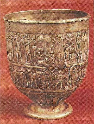
Silver bowl with a ritual scene. Trialeti. 2000-1500 BC.
However, in Assyria, there is a certain internal stabilization — Tiglagpalasar III comes to power, who strengthened the combat power of the Assyrian army. In 734 BC, the armed forces of Assyria engage in battle with the Urartu-led coalition in Northern Syria near the city of Arpad. The allies are defeated, and Sarduri retreats to the native lands of his power. In 735 BC, Tiglath-Pileser III strikes at the heart of the Urartian state, in the area of Lake Van. A number of central districts were put to the fire and sword.
But the fight wasn’t over. King Rusa I (735-713 BC) sought to revive the power of Urartu. In foreign policy, he tried to avoid open confrontation with Assyria, while at the same time supporting anti-Assyrian sentiments everywhere. Carrying out an active policy in the south also made it difficult for the Cimmerians to invade the northern regions of Urartu. But the Urartian possessions in Transcaucasia were systematically expanded, and new cities were founded. Great work on the creation of a powerful economic complex was carried out by Rusa I in the area north of the city of Urmia. The king did not forget the traditional center of his state — the area of Lake Van. An extensive reservoir was built there, vineyards and fields appeared, and a new city was built, called Rusakhinili.
Seeing with what energy Rusa I was strengthening the power of Urartu, Assyria hastened to strike a new blow. The campaign was carefully prepared. In 714 BC, Assyrian troops led by Sargon II moved into the area east of Oz. Urmia against the local rulers, artfully set against Assyria by the Urartian king. But Rusa I also found the moment convenient for a decisive battle and tried with his army to go to the rear of the army of Sargon II. The battle ended with the defeat of the Urartians. As a result of this campaign, Urartu was defeated in the struggle for political hegemony in Western Asia and ceded this role to Assyria.
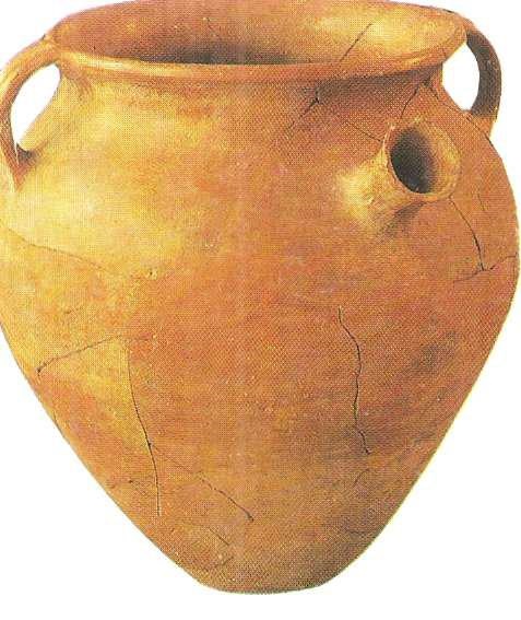
Bomb-shaped vessel. Urartu. VIII century BC.
However, in the future, both sides avoided direct clashes. Under these conditions, Argishti II (713-685 BC) directed his campaigns to the east, reaching the coast of the Caspian Sea. Here the traditional policy of the Urartian kings continued — the conquered regions were not ruined, but submitted on the terms of payment of tribute. Argishti II also carried out irrigation works in the central regions of the Urartian empire — near Lake Van. This stable situation continued under Ruse II (685-645 BC).
Apparently, Ruse II managed to conclude an alliance with the Cimmerians, together with whom he makes successful campaigns in Asia Minor. In Transcaucasia, he conducts large irrigation works and builds the above-mentioned city of Teishebaini. However, the threat to Urartian power lay in a new force — in the Scythian nomadic tribes that penetrated into the Front Asia and created their own “kingdom”in the 670s BC. The Scythians defeated Urartu’s allies, the Cimmerians. Apparently, a number of districts of Urartu were also affected at the same time.
After all, these attacks were all the more dangerous because they affected the deep rear of the Urartian power, which remained almost inaccessible to the Assyrian army. Urartu is noticeably weakening and losing its previously strong position in the international arena. Construction activity continues in the Vansky district and in Transcaucasia, but its scale is decreasing. At the beginning of the VI century BC. e. Urartu falls into vassalage from the new powerful state of the ancient East — Media, and by 590 BC ceases to exist as an independent state.
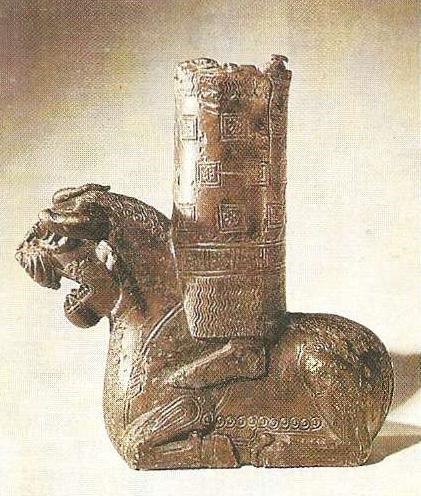
A monster that serves as a footstool for God. Detail of the throne of the Urartian deity. Bronze, inlaid with gold. Rusakhinili. VIII-VII centuries BC.
The Urartian state paid great attention to the development of the economy, especially taking care of the irrigation channels and the construction of reservoirs. Tsarist farms played a significant role in the economy. During the construction of Teishebaini, Rusa II simultaneously conducted a canal and created extensive agricultural land. According to approximate estimates, the granaries and wine warehouses of Teishebaini were designed for products obtained on the territory of 4-5 thousand hectares. According to cuneiform inscriptions, the staff of the royal household in Rusakhinili was estimated at 5,500 people. In the royal farms, the processing of agricultural products was carried out, and craft workshops worked. Much less important were the temple farms.
The achievements of the Urartians in the field of culture were remarkable. The history of Urartu is the history of the urbanization of Transcaucasia. The territory of cities is usually quite large — from 200 to 300 hectares (Argishtikhinili even 400-500 hectares). Cities, as a rule, were created at the foot of high hills, the tops of which were occupied by citadels. The layout of some Urartian cities was regular, for example, in Zernakitep. Apparently, a rectangular planning system also existed in Teishebaini. City builders sought to ensure that the boundaries of urban development coincided with natural obstacles (river, steep hillsides, etc.). The defensive systems of cities consisted of one, more often two, and sometimes three lines of walls. City walls 3.5-4 m thick were usually equipped with buttresses and massive projecting square towers.
Urartian palaces were of two types. The basis of the composition of the palace in Yerebuni is made up of two courtyards, around which there are rooms for various purposes. One of the courtyards is surrounded by a colonnade, and all the most important rooms of the palace are grouped around it. The core of the second type of palace is the pillared halls. The palace complex of the western citadel of Argishtikhinili was divided into two parts: the ceremonial-residential and economic. The center of the front part was a large pillared hall (two rows of ten columns). The temple architecture of Urartu is very diverse. The temple of the god Haldi in Yerebuni consists of a main oblong hall with a columned portico in front of it and two square rooms, one of which is a tower. This type is similar to the Hurrian-Mitanni structures. The most common, however, is another type of temple: a square one-room building built on a platform, with corner projections and a tent-shaped crosshair. Another type of temple is known only from its reproduction in relief. This is the famous Assyrian relief depicting the capture of Mutsatzir. The temple in Mutsatsir resembles the ancient ones.
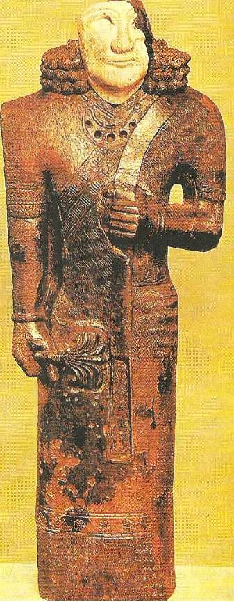
Caryatid. Detail of the throne of the Urartian deity. The stuff of the God Haldi. Urartu. Rusakhinili. VIII-VII centuries BC.
The monumental art of Urartu is represented by stone reliefs, round sculptures, and wall paintings. The stone sculpture is divided into two distinct groups. One of them is the monuments of Urartian sculpture proper, which are connected with the traditions of the art of the ancient Near East. However, the finds of this sculpture are very rare. In particular, a damaged statue made of gray basalt found in Van has been preserved, apparently depicting one of the first Urartian kings. Much more common is folk sculpture of the “traditional-conventional style”, which continues the traditions of Bronze Age sculpture. The monumental reliefs are best known from the finds in Adyldzhevaz, where, apparently, a procession of the gods was presented.
Urartian wall paintings are the most studied. The painted panels were arranged in the form of often alternating horizontal stripes— ornamental and pictorial. Urartian murals are included in the general circle of ancient Near-Asian monumental painting. They are characterized by a great conventionality and canonicity, which is reflected in the use of certain stereotypes in the depiction of living beings and plants, the use of a certain, strictly limited set of themes (images of deities, kings, ritual scenes predominate), a very strong symbolism that binds together both pictorial and ornamental motifs.
The Urartians achieved great skill in the applied arts, especially in the production of works of art made of bronze. This was achieved, in particular, due to the high technical level of Urartian metalworking.
The works of the Urartian Toreutics were extremely popular. Their findings are recorded in Asia Minor (in particular, in Gordion), on a number of islands of the Aegean Sea (Rhodes, Samos), in mainland Greece (Delphi, Olympia), even in Etruria. Bright examples of Urartu art are ceremonial shields, helmets, quivers, which served as offerings to temples. They were decorated with relief scenes (images of horsemen, war chariots, sometimes there are also sacred scenes). During the excavations, a large number of gold and silver jewelry of a high artistic level was also found.
The Urartian culture played an exceptional role in the subsequent destinies of the culture of the entire Front East. Its greatest achievements were received by Media, then by Achaemenid Iran, and spread widely throughout the Near and Middle East.
In the post-Urartian period, the formation of class society and statehood was completed in three more Transcaucasian centers: Colchis, Iberia and Albania. Here, as well as in the historical successor of Urartu — the ancient Armenian kingdom, a powerful impulse from the ancient civilization is later added to the local and Ancient Eastern cultural traditions. This general pattern of historical and cultural development was carried out in the complex political situation of the formation and collapse of new states, military campaigns and diplomatic alliances.
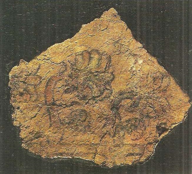
Wall painting with ornaments. Urartu. Erebuni of the VIII century BC.
Thus, in general terms, the periodization of the civilizations of Transcaucasia currently looks like this:
A significant part of the former Urartian possessions became part of the Median power, and then the Achaemenid Empire. They were incorporated into several satrapies, paid a tax to the central government, and supplied armed contingents to the Achaemenid army. Within the framework of such satrapies, in the VI-V centuries BC, the ancient Armenian nation was formed, gradually including the descendants of the Urartians and some other tribal groups. The Achaemenids were widely involved in the management of the local nobility. Soon, the rulers of one of the satrapies were representatives of the ancient Armenian nobility-the Yervandids (Orontids in the Greek transmission). The culture and life of the satrap and his entourage followed Achaemenid patterns. In Erebuni, the Urartian buildings were re-planned in such a way that they formed a large 30-column hall-a local echo of the royal ceremonial halls of Persepolis and Susa. Cultural and trade relations are expanding — during the excavations of Yerebuni, Greek coins of the V century BC were found. Ancient Iranian religious ideas, and in particular, apparently, Zoroastrianism, have a significant influence on ancient Armenia. However, the mass, popular culture largely continues the Urartian traditions.
The capital of the Yervandid possessions was Armavir, located on the territory of the earlier Urartian center. The relatively short-lived independence of Armenia came to an end in 220 BC, when Antiochus III annexed this state to the so-called Great Armenia, created by him within the Seleucid state. In the second century BC, during the period of the weakening of this state, in the areas west of the lake. Van forms an independent state of Sofen, headed by Zariadr (Arm. Zareh), between Van and Sevan there is another state, officially called Armenia. Its first king was Artashes I (Greek. Artaxias), the founder of a new dynasty — the Artashesids. Artashes I himself (189-161 BC) paid much attention to the improvement of the new state, in particular, a new capital, Artashat, was founded near Armavir.
Around 95 BC, the Parthians promoted the accession of Tigranes II to the Artashesid throne, but he proved to be a skilled and far-sighted politician and soon pushed the Parthians himself. The short-lived “rise” of the ancient Armenian kingdom begins. In Syria, Tigranes II subdued part of the former Seleucid possessions to the southwest of Oz. Van, in the foothills of the Armenian Taurus, founded a new capital — Tigranokert, created according to the type of Hellenistic Greek polis. The title “king of kings”, which Tigran II soon assumes, was quite natural — under him, Armenia really turned into a major power.
However, the general situation in Front Asia continued to remain tense. Tigranes II was forced to yield to the Roman onslaught, and in 66 BC a peace treaty was signed with Pompey in Artashat. The borders of ” Greater Armenia “were cut, and the” king of kings “recognized himself as”a friend and ally of the Roman people.”
The successes of the Parthians, and in particular the decisive victory over Crassus at Carrhae in 53 BC, contributed to some strengthening of the independence of the Armenian state, but soon the campaigns of Antony again reduced the country to the status of a Roman vassal.
The activation of Rome in the east almost primarily affected Armenia. In 114 AD, under Trajan, Armenia was declared a Roman province for a short period of time. Numerous revolts and pressure from Parthia forced Hadrian to withdraw the Roman garrisons, and from the second half of the second century AD, Armenia became practically independent. The Sassanids, who succeeded Parthia, tried to subdue Armenia, but met with a firm rebuff. The state with ancient traditions sought to establish ideological independence, which was, in particular, associated with the adoption of Tiridates III (287-330 AD).) as the state religion of Christianity, which began to spread in Transcaucasia from the second century AD.
Armenia in the last centuries BC and the first centuries AD was a country of high culture. A clear indicator of this is the process of urbanization. Ancient Armenian cities were founded according to all the rules of Hellenistic urban planning. Typical, in particular, is the regular layout of city blocks.
The rise of urban planning, of course, contributed to the development of architecture. Advanced Hellenistic and Roman construction techniques and types of buildings were borrowed. The temple in Garni, recently completely restored, is widely known. It is a peripterum (24 columns) of the Ionic order, standing on a high podium. The roof was gable, the facade was decorated with a pediment. During the restoration work, it was found out that the ceiling on the roof of the temple was vaulted. The temple was probably built in the first century AD and is dedicated to the god Mihr. Very interesting is the Garni bathhouse, the floor of one of the rooms of which was decorated with mosaics.
The sculpture of Armenia is characterized by a great variety. Here are found both magnificent imported works of Hellenistic sculpture, and very simple, schematic statues-a continuation of the previous folk tradition. But the most popular was the artistic movement, which was an organic fusion of Hellenic and local artistic principles.
Cauldron ornament. Bronze. Urartu. VIII century BC.
Armenian coroplasty was a striking phenomenon. The terracotta figurines found in Armavir and Artashat represent female and male figures, images of horsemen, musicians, etc. The coroplastics of Armenia resemble the coroplastics of Mesopotamia of the Parthian period, but differ in a number of peculiar and original features. The level of metalworking and related branches of art was high: torevtiki and jewelry business.
The spiritual life of ancient Armenia is less well known. It can be assumed that during this period there was a significant difference between the nature of the culture of the royal court and the top of the ruling class, on the one hand, and the culture of the main part of the population of Armenia, on the other. While the former proved highly susceptible to Hellenistic and Parthian cultural influences, the latter remained faithful to local age-old traditions. In the spiritual culture of the people, apparently, an important role was played by the heroic epic, the echoes of which were preserved in Movses Khorenatsi and in the epic cycle about David of Sasun.
The religion of Armenia was characterized by syncretism, it merged ancient local cults and Iranian influences.
The most important place in the pantheon was occupied by the deities Mihr, Anahit and Vahagn. The kings sought to create and widely spread the cult of the dynasty, which was to serve as a means of uniting the population under the rule of the Armenian rulers.
A special place in the history of Transcaucasia was occupied by Colchis. The history of Colchis in ancient times is covered by ancient written sources, significant information is provided by archaeological research (especially the works of O. D. Lordkipanidze and G. A. Lordkipanidze), and epigraphic finds have recently been made. Unlike other areas of this region, it was more closely connected with the world of Mediterranean cultures and in the VI century BC became the object of Greek colonization.
The problem of Greek colonization in Colchis is one of the most controversial in modern science. There are three points of view –
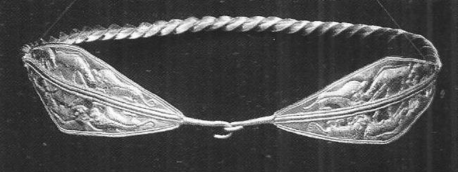
The main obstacle to the wide expansion of the Greeks was the fact that by the time they arrived in Colchis, a local state formation had already developed here. One of the most important prerequisites for its emergence was the rapid development of the productive forces in the early Iron Age. Colchis became one of the most important centers of iron metallurgy. The sharp social differentiation in Colchis is revealed on the materials of the burials. Thus, only one female grave of the V century BC contained more than 1,600 gold items, including magnificent diadems with the image of lions tormenting a bull and a gazelle.
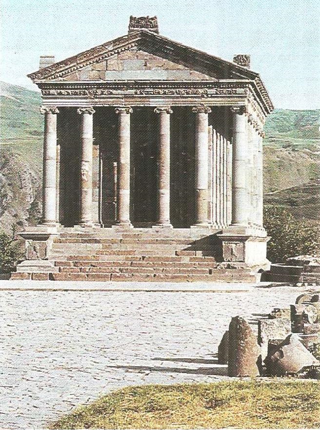
Pagan temple. Gurney. I-II centuries AD.
Urban-type settlements are also formed in the mainland, far from the coast (Vani, etc.). The basis of the heyday of Colchis was a variety of crafts and developed trade. The products of local craftsmen made of iron and gold were particularly perfect. It is not for nothing that the idea of Colchis as the land of the “golden fleece” was established in the ancient world; the adventures of the Argonauts who came to Colchis for it are one of the most popular themes of the Greek epic.
Flax and hemp were produced for export, and, as ancient geographers, in particular Strabo, specifically noted, the country was “remarkable for everything necessary for shipbuilding”. Trade was not only local, but also transit, and it was believed that representatives of 70 tribes and nationalities converged for trade in Dioskuriad. The early development of money circulation was also connected with this circumstance. On the coast, coins of various Greek cities were widely distributed, and in the interior of Colchis, coins of local issue prevailed, called by modern researchers “Colchis”. These coins have a bust of the ruler on one side and a bull’s head on the other. The release of “colchis” in the V — first half of the III century BC testifies to the developed commodity-money relations and, according to a number of scientists, to the existence of an independent Colchian state. Gold coins minted in the name of the local king Aka belong to the III century BC. Administratively, Colchis was divided into a number of provinces, headed by persons who bore the title of skeptukhs (“scepter-bearers”).
The most remarkable feature of the culture of ancient Colchis was the interaction of indigenous and Greek traditions. In the coastal centers, and possibly also in Vani, Greek artisans from Sinop, Heraclea, and other centers worked. During the excavations in Vani, many Greek amphorae and other imported products were found. Colchis also received highly artistic works of ancient art: painted ceramics, marble sculpture, etc.
The most important materials for judging the nature of the culture of Colchis were provided by the excavations of Vani. The city consisted of two parts: The “acropolis”, located on a high triangular hill, and the “lower city”, which lay at the confluence of the Sulori and Rioni rivers. The acropolis was well fortified. The system of its fortifications testifies to a deep knowledge of the then advanced principles of Hellenistic fortification. At the same time, local features are also noticeable — at the city gate on the outside there was a statue of the guardian goddess of the city.
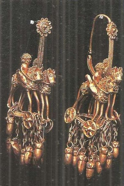
Gold earrings. Colchis. V century BC.
Several structures are open on the territory of the acropolis. The study of the architectural monuments of Vani shows that the local architects were well acquainted with the achievements of Hellenistic architecture and urban planning. The influence of Greek architecture primarily affects the construction equipment (rusticated blocks, the widespread use of roof tiles, mosaic floors). Elements of the order architecture are also being introduced (bases of the Attic profile, capitals of the Corinthian order, architraves, sims in the form of lion heads, coffered ceilings).
The introduction of elements of the Greek order, however, did not change the essence of the local architecture. The order was perceived as a decorative system, while the designs themselves remained traditional. Especially significant in this respect are the tower-like sanctuaries, which go back to the ancient local prototypes.
Colchis was the center of a peculiar field of art. Here the presence of stone and bronze sculptures is recorded, small statuettes, including silver ones, are found, there are monuments of coroplastics, toreutics, glyptics. All spheres of art are characterized by a fusion of local and Greek artistic traditions.
As the influence of Rome spreads in the east, Colchis also falls into the orbit of its influence. Included in the possessions of Mithridates VI of Pontus, after the defeat of this ardent enemy of the Romans, it becomes dependent on the victors. Roman garrisons are located in the coastal cities. In 63 BC, Pompey claims a certain Aristarchus, who minted his own coin, as the “king of the Colchians”. In the first century AD, the coastal areas called the Polemonian Pontus formed a Roman province.
Colchis soon became part of the Roman province of Cappadocia.
In the III-IV centuries AD, Western Georgia was called Lazika in ancient sources, although the locals called their country Egrisi. The capital was Archeopolis. Since the beginning of the IV century, Christianity has been spreading here.
An important and unique state formation of the Transcaucasus of the ancient era was Iberia. The Eastern Georgian kingdom of the ancient era (III century BC-III-IV centuries AD) was called Iberia by the Greco — Roman authors. Medieval Georgian sources call it Kartli. Iberia occupied mainly present-day Eastern and Southern Georgia. However, over time, it was able to master some areas of Colchis. The history of Iberia is known to us from the reports of ancient authors, a few inscriptions. But in recent decades, extensive archaeological work has been carried out, which has provided a new rich material, which is being actively studied (the studies of G. A. Melikishvili, O. D. Lordkipanidze, A.V. Bokhochadze, and Yu.M. Gagoshidze are very interesting in this regard).
In the Hellenistic era, the formation and strengthening of the state in Iberia took place. An interesting temple complex of that time (II-I centuries BC) was explored in the area called Dedoplis-Mindori. Excavations revealed a grandiose system of simultaneous buildings, representing a rectangle with an area of about 6 hectares, surrounded by a wall. Its longitudinal axis is oriented along the north-south line. In the southern part of the complex was the main temple (46×30 m) — a four-column square hall with a quadrangular platform for the altar in the center. The hall and the large portico leading to it are surrounded on three sides by a system of corridors. The main rectangle of the temple is flanked from the north by a room of the ivan type — an open portico with two columns. A small temple is located 90 m north of the main temple.
Strictly symmetrical in relation to the temples are the eastern and western gates, which are extensive propylaea with six columns, consisting of two unequal porticos — external and internal.
Researchers (in particular, the head of the excavations Yu. M. Gagoshidze) believe that this vast temple complex was dedicated to the gods of the Mazdeist circle, largely merged with the ancient local Georgian astral deities, and that the main temple was dedicated to a deity like the Avestan Ardvisura Anahita.
Archaeological research in recent decades has provided insight into the character of Iberian cities in the first centuries of our era. According to the ancient Georgian historical tradition preserved by Leontius Mroveli, the first king of Iberia — Parnavaz-began to build his residence on Mount Armazi, where he also erected an “idol” (i.e., a statue) in his honor. According to the same tradition, subsequent kings continued to build here. The mountain became an acropolis. The Georgian tradition is consistent with the data of such ancient authors as Strabo and Pliny the Younger. This city is located on the Bagineti hill. Archaeological excavations have revealed defensive walls, palace and public buildings, and tombs. Archaeologists have uncovered the ruins of a number of other cities in Iberia (in Sarkin, Dzalisi, Urbnisi, etc.). There were also so-called cave cities, such as Uplistsikhe.
Palace-type buildings have been opened in Bagineti, Armazishavi, and Dzalisi. Thermae with a typical Roman structure have been found in several places. The architecture of Iberia has reached a very high level of development. Already in the early centers (for example, in Samadlo), such a complex technique as terracing the slopes of the hill was used. In the construction of buildings, the rule was a combination of stone and raw brick; from the first centuries of our era, especially in the construction of thermal baths,— baked brick. Shingles were widely used. Columnar structures and toroidal bases were popular in Iberian architecture.
Particular attention is drawn to mosaics, among which the most interesting panels from Dzalisi. The thermal baths feature plant scenes, images of fish, dolphins, and shells. In the palace room, however, there are magnificent mosaic scenes depicting Dionysus and Ariadne, various characters of the Dionysian circle, rich floral and geometric ornaments, and explanatory inscriptions.
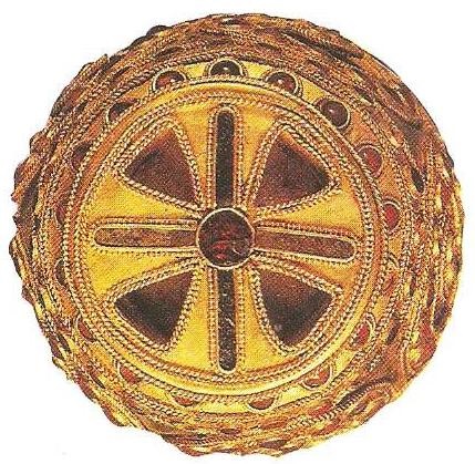
Golden diadem. Colchis. V century BC.
Dionysus and the Dionysian cult were very popular in Iberia. This is evidenced by many finds of works of art. For example, during the excavations of Sarkine, terracotta masks depicting Dionysus and Ariadne, and statuettes of the Dionysian circle were found of excellent quality. It is likely that the terracotta masks were used to decorate the interior of a building and were hung on the wall in one row: this is evidenced by small holes for the cord. Toreutics, glyptics, and jewelry also developed in Iberia.
Caucasian Albania was located further from the centers of the Greco-Roman world than other regions of Transcaucasia, and therefore its history and culture were poorly covered in the works of ancient authors. Epigraphic materials are also almost completely absent. Because of this, archaeological finds are of particular importance. Among the rather numerous studies on the history of Caucasian Albania, a special place is occupied by the works of K. V. Trever, I. G. Aliyev, I. A. Babayev, J. A. Khalilov, and others.
The problem of the time of the formation of statehood and class society in the territory of Caucasian Albania is still debatable, but we can assume that this process ends in the Hellenistic era. Albania was less affected by the Roman expansion than other countries of Transcaucasia, although the Romans penetrated here in the first century BC (Pompey’s campaigns), and later. One of the evidences of this is a Latin inscription of the end of the first century AD, written on behalf of a centurion of the XII Legion, found in the mountains of Gobustan, near Baku. Later, the Arshakid dynasty seized power in Caucasian Albania. Albania was more or less involved in the Roman-Parthian confrontation in Transcaucasia.
The prerequisites for the emergence of cities in Albania were formed by the middle of the first millennium BC.In the first century AD, Kabala became the largest urban center and capital of the country. Archaeological studies have shown that the total area of the city reached 50 hectares. In addition, urban centers of ancient times are recorded in Shamakhi, Mingechaur, Tazakent and in the northern part of the country, on the territory of Dagestan (Derbent, etc.).
During the excavations, for example, in Kabala, ordinary dwellings and public buildings were investigated. Wood, raw brick, and stone were used in the construction. Popular in the construction of large buildings were columns, the bases of which were usually made of stone, and the trunks – of wood. Rich residential buildings, as well as public buildings, were covered with tiles. In Albania, agriculture, handicrafts, and trade developed. The medium of circulation was a local coin-an imitation of the drachmas of Alexander the Great. The time of the beginning of the minting of these coins remains an object of discussion.
Sculpture was a popular art form. A number of very conventionally executed statues have been found, undoubtedly going back in their techniques to the ancient prototypes. Apparently, they are of a cult nature. Small bronze sculptures are quite widespread. Figurative ceramics are extremely elegant. Ancient potters gave vessels anthropomorphic and zoomorphic forms in the form of a goat, a rooster, a deer, a bull, etc. Anthropomorphic vessels are found only in the area of Shamakhi. Coroplasty also developed in parallel. The most popular images were of nude women. During the excavations of Kabala, a large collection of clay bulls with images of both Hellenistic (Hercules) and local types (horsemen, various animals) was found. From the Roman Empire, glass, bronze vessels, jewelry, etc. penetrated into Caucasian Albania.
Religion played a significant role in the life of Albania. The supreme triad of gods included, according to Strabo, Selene, Helios, and Zeus (Strabo names the Greek equivalents of the local deities). The high priest is the second person in the state after the king, “he stands at the head of a large and densely populated sacred area, and also disposes of the slaves of the temple.”
The ancient civilizations of the Transcaucasus, with all the originality of each of them, had a number of similar features, generated both by the proximity of the socio-economic system, and the commonality of historical destinies and long-term mutual contacts. They went through a long historical development, interacting first with the Ancient Eastern civilizations, then with the Hellenistic world, and finally with the Roman Empire and Parthian (and then Sasanian) Iran. History has assigned them a task of great importance — they served as a reliable shield for the civilizations of the Front East from the north, protecting them from the numerous and warlike nomadic tribes that lived in the steppes beyond the Caucasus Range and repeatedly made campaigns to the south.
Under constant pressure from both the south and the north, the peoples of Transcaucasia were nevertheless able to create, preserve and develop their deeply original civilizations, which organically merged both the oldest cultural traditions and external influences, which were mastered and processed in such a way that they became an important component in the common treasury of world culture.
The vitality of cultural traditions is one of the most striking and striking features of the civilizations that developed in ancient times in Transcaucasia.
Tell your friends:
Rating:
 (No ratings yet)
")


")